Geology of the Czech Republic
| Stránky: | Moodle ZČU |
| Kurz: | CBG/FGCRZ - Fyzická geografie ČR |
| Kniha: | Geology of the Czech Republic |
| Vytiskl(a): | Nepřihlášený host |
| Datum: | pondělí, 9. listopadu 2026, 03.16 |
1. Introduction
Small area of the Czech Republic has varied geology and tectonic development. The area of CR is subdivided in two geological units - the Bohemian Massif and the Western Carpathians, and its development involves a long time period from the Paleoproterozoic to the recent period, i.e. about 2.1 billion of years.
The Bohemian Massif is a significant and extensive fragment of the Variscan orogen formed during the Devonian and the Carboniferous (over the interval c. 380-320 Ma). The eastern part of Moravia and Silesia belong to the Western Carpathian orogen, which is one of sub-parts of the Alpine orogen—a vast mountain system of southern Europe. It was formed by collisions of continental fragments situated between the northern edge of Africa and the so-called Epi-Variscan Platform of Western Europe during the Mesozoic and the Tertiary.
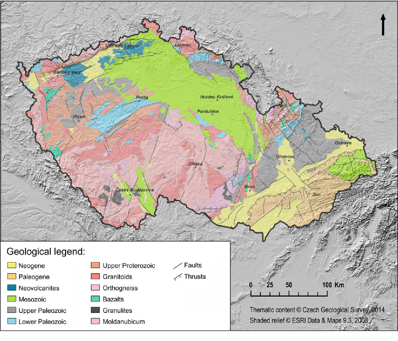
Fig. 1. Simplified geological map of CR (Source: Czech Geological Survey in Pánek a Hradecký Eds., 2016). The boundary between the Bohemian Massif and the Western Carpathians is the right edge of the Neogene rocks (yellow) in the eastern part of the CR.

Fig. 2. Extremly simplified geological map.
From the geological point of view it is important to realize that the territory of the CR:
- did not always have its current geographical location
- did not always have the temperate climate
- did not always have the current elevation and relief
- wasn't always a dry land
Further reading
Grygar, R. Geology and Tectonic Development of the Czech Republic. In Pánek, T. a Hradecký, J. (Eds.) Landscapes and Landforms of the Czech Republic. Switzerland: Springer International Publishing, 2016, p. 7-18.
2. The Bohemian Massif
The Bohemian Massif is a fragment of the vast Variscan orogen which was formed during the Palaeozoic. It is composed of four separate regional domains which are covered by younger Mesozoic sediments in the Central part and predominantly Cenozoic (Paleogene and Neogene) rocks in the east.
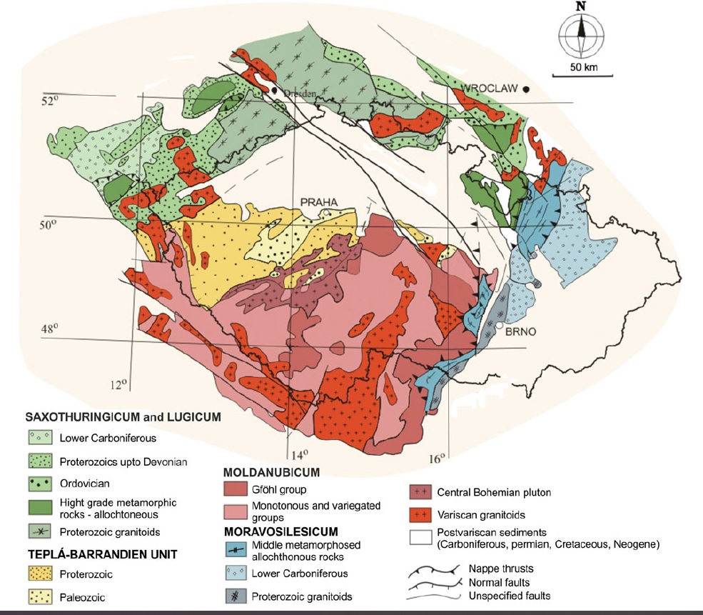
Fig. 1. Four main Variscan regional units of the Bohemian Massif. Cretaceous postvariscan sediments cover the majority of the central Bohemia, Neogene sediments cover the eastern part of the Czech territory (source: Pánek et Hradecký Eds., 2016).
During the oldest geological times (Proterozoic) the Bohemian Massif was situated in the area of low southern latitudes on the northern edge of Gondwana (one of the so called supercontinents). The marine environment was present. The Variscan orogeny join the four mentioned units and the Bohemian Massif was gradually transformed into a platform unit. During the Carboniferous, it became dry land. In the most of the area, with the exception of intramontane depressions, deep erosion of the Variscan basement took place. Erosion and continental sedimentation were interrupted only for a short time by a marine transgression over part of the area in the Jurassic, Cretaceous and Neogene Periods. In the Late Cretaceous, a part of the Bohemian Massif subsided along the faults of the Elbe Fault Zone and became a site of at first continental and later marine sedimentation in the Bohemian Cretaceous Basin.
A significant milestone in geological development of Bohemian Massif occured during the Mesozoic and the Tertiary when faults and tectonic zones, created by the Variscan orogeny, were reactivated, which reacted to changes in the stress regime in the lithosphere in the course of so-called Saxonian tectonics due to deformations in the foreland of the Alpine orogen.
The present-day volcanic relief is a relic of volcanic activity occuring from Cretaceous to Quaternary during the above mentioned Saxonian tectonics. Main neovolcanic areas are in the western and northwestern Bohemia (Doupovské hory/Doupov Mts., České středohoří/Central Bohemian Uplands) and in north Moravia (Nízký Jeseník).
In the Quaternary the Bohemian Massif was a dry land and, after the regression of the sea from the Carpathian Foredeep in the Tertiary, both units - the Bohemian Massif and the Western Carpathians develop under the same conditions.
Further reading:
Grygar, R. Geology and Tectonic Development of the Czech Republic. In
Pánek, T. a Hradecký, J. (Eds.) Landscapes and Landforms of the Czech
Republic. Cham: Springer International Publishing, 2016, p. 7-18.
3. Western Carpathians
The Carpathians are one part of the Alpine orogenic belt (vast orogenic belt extended from Spain to south-eastern Asia). They create an arc of Alpine mountains which extend from Austria to Serbia (subdivision of Carpathians).
The Western Carpathians can be found in the easternmost areas of Moravia and Silesia. The development of this orogenic belt began shortly after termination of Variscan orogeny during the Mesozoic. The Western Carpathians are divided in three parts - the Inner (south), Central and Outer (north). Only Outer Western Carpathians occur in the territory of the Czechia. It is represented by two flysch complexes (rhythmically bedded units of coarse- and fine-grained sedimentary rocks) and the Carpathian Foredeep (serie of basins between the Bohemian Massif and Carpathian Mountain belt represented by Hornomoravsky uval, Dolnomoravsky uval and Dyjskosvratecky uval).
The Czech part of the Outer Western Carpathians is build of Mesozoic till Neogene sedimentary rocks such as sandstones, claystones, siltstones, coarser-grained clastics and limestones.
The most significant orogeny units of the Czech Outer Western Carpathians are e.g.: Moravskoslezske Beskydy, Javorniky, Bile Karpaty.
Further reading:
Grygar, R. Geology and Tectonic Development of the Czech Republic. In
Pánek, T. a Hradecký, J. (Eds.) Landscapes and Landforms of the Czech
Republic. Cham: Springer International Publishing, 2016, p. 7-18.