Geomorphologic evolution and landforms
| Site: | Moodle ZČU |
| Course: | CBG/FGCRZ - Fyzická geografie ČR |
| Book: | Geomorphologic evolution and landforms |
| Printed by: | Guest user |
| Date: | Monday, 9 November 2026, 9:27 AM |
1. Introduction
The Czech Republic is due to the geotectonic and geologic history and diversity exceptionally rich in landforms which originated throughout completely different time scales. Main factors which influenced such high diversity are tectonics, lithology and climate.
Similar to geological division the territory of Czech Republic is composed of two main geomorphic units/provinces - the Czech Highland and the Western Carpathians - and two minor units - Central European Lowland and West Panonnian Basin.
Four chronological milestones of long-term relief evolution can be distinguished in the Czech territory:
- Variscan orogenetic processes
- Late Cretaceous transgression and deposition of a thick sedimentary pile across a vast part of the Bohemian Massif
- Alpine and Carpathian orogenetic processes and follow-up neotectonic activity in the Bohemian Massif since the Late Cretaceous
- Volcanic activity in the Eocene-Pleistocene time span

2. Pre-Quaternary Evolution
At the end of the Variscan orogenetic processes (Permian period) the Bohemian Massif was a mountainous terrain similar to today Alpine mountains. Intensive denudation processes reduced the mountain terrain to a planation surface (flat terrain or slightly undulating landscape) already during the Permian. For most of the Mesozoic we have poor evidence of geomorphic evolution of Czech landscape.
The marine transgression during the Late Cretaceous was a milestone for contemporary landforms. This transgression caused burial basement rocks by a thick pile of clastic deposits. We call the area covered by this deposits the Bohemian Cretaceous Basin. Till today it is flat lowland where the important agricultural activity is situated. The sandstones are dominant rocks in this area and later they were sculptured by weathering ans erosion in famous "rock cities".
Orogenic processes in the Alps and Carpathians induced major tectonic rejuvenation in the Bohemian Massif. We call it neotectonics and it led to the formation of the characteristic horst-and-graben structure of the Bohemian Massif with an elevated rim of mountains enclosing a rather stable or slightly uplifted Bohemian Basin. The Tertiary in Central Europe was characteristic by a warm and humide climate, deep weathering formed kaolinitic mantles (e.g. nort of Pilsen where the kaoline is mined). The most important stage in evolution of caves in the Bohemian Massif occurred also during the Tertiary. Neotectonics during the Terciary caused also massive massive volcanic activity which formed the Ohře/Eger rift at the southeastern foothills of Krušné hory (Eger Mts.). Majority of the volcanic products were removed by erosion, but the remnants of sub-volcanic bodies form characteristic landscape in the NW and N parts of the Czechia (e.g. České Středohoří and Doupovské hory).
Main features of recent major valley networks were established during the Late Tertiary but still they were a bit different than today's network, e.g. south Bohemian rivers flew to the catchment of upper Vltava which was drained off to the Alpine Foreland and not to the north to Labe River.
The eastern part of the Czechia formed by the Carpathians started its subaerial evolution not until the Miocene and gross land surface of the flysch Outer Western Carpathians is hardly older than 15 Ma.
Further reading:
Pánek, T., Kapustová, V. Long-Term Geomorphological History of the Czech Republic. In
Pánek, T. a Hradecký, J. (Eds.) Landscapes and Landforms of the Czech
Republic. Switzerland: Springer International Publishing, 2016, p. 29-39.
3. Quaternary evolution
The Quaternary landscape evolution is closely connected with the climate changes during the Pleistocene when primarily the river valley with system of river terraces, glacial and periglacial landforms were formed.
This will be described in depth in Chapter Quaternary landscape evolution.
4. Types of landforms
There are many different genetic types of the landforms in the territory of the Czech Republic. The Czech landscape is the result of impact of many different geomorphic factors such as flowing water, wind, glaciers or gravitation on the geological fundament.
Here are briefly presented some of the most important and interesting types of landforms which can be found in the Czechia.
4.1. Structural landforms
Structural landforms or rock relief is linked to the solid rocks disrupted by faults or fissures.
The system of fissures (direction) predetermines the character and shape of the landforms. This type of landforms could be connected with many rock types (e.g. granite, sandstones or volcanic rocks).
The rock formations in sandstones are the most significant in the Czech Republic. The areas where the dense cumulation of sandstone forms is present are called "rock cities". It is a complex ("labyrinth") of solitary rock towers and cliffs which are separated by narrow gorges, cracks, or crevasses one from another. These sandstone rock cities are primarily linked to the Bohemian Cretaceous Basin.
Also the Terciary volcanic relief is very impressive. Most of the volcanic features is concentrated in the NW Bohemia along the principal tectonic structure - the Ohře/Eger Rift. The postvolcanic activity (e.g. thermal and mineral springs in Karlovy Vary, "mud volcanoes" in Soos protected area) is also present here.
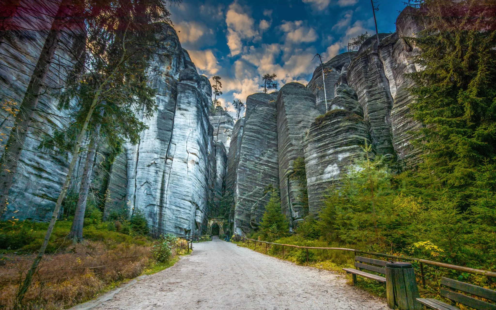
Fig. 1. Adršpach-Teplice sandstone rock city (www.travelking.cz).
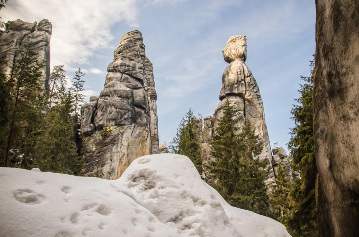
Fig. 2. Sandstone rock towers "Starosta a Paní starostová" (Mayor and Mrs. Mayor) in Adršpach rock city (https://www.kudyznudy.cz/aktivity/skalni-mesto-u-adrspachu).

Fig. 3. The biggest granite boulder in the Czech Republic called Bába (Old woman), situated northward of Pilsen near town Žihle. Residual granite rock forms can be found in many places of the Czech territory. They have been exposed by million of years long period of weathering.

Fig. 4. Granite rock forms along the "Medvědí stezka" trail in the Šumava Mts., (https://www.turistika.cz/vylety/medvedi-stezkou/detail).

Fig. 5. Ostrá hůrka, lydite rock formation between Pilsen and Starý Plzenec. Lydite is very resistant Proterozoic silicite.

Fig. 6. Map of neovolcanic areas (http://www.gweb.cz/clanky/clanek-61/).

Fig. 7. Panorama of the České Středohoří Mts., volcanic area in NW Bohemia. The hills are not the volcanoes but the remnants of sub-volcanic bodies (autor: Záhorec Pavel, https://itras.cz/ceske-stredohori/galerie/1784/#foto).

Fig. 8. So called "mud volcanoes" in Soos protected area near the town Františkovy Lázně are the landforms created by the eruption of mud , watter and gases.
4.2. Karst landscape
This type of landscape is closely connected with the geological conditions. The karst landforms can develop only in soluble rocks such as limestones, dolomite, marble or gypsum which can be dissolve by water.
There are many karst areas in the territory f the Czech Republic but they are small in extent and scarce in karst forms such as caves or sinkholes. Nevertheless they are two larger karst areas, one in the Bohemia - the Bohemian Karst, and second in Moravia - the Moravian Karst. They occur in Silurian, Devonian or Jurassic carbonates which weathered during the Mesozoic and Tertiary.
The Bohemian Karst extends 35 km to the SW from the southern part of Prague (it is a protected landscape area). Most of the karst forms here are inactive and largely sediment-filled The area is poor in karren fields, dolines and underground active streams, but rich in complex maze caves, locally with small but deep cave lakes. The area has extraordinary palaeogeological importance. The continuous Palaeozoic sedimentary rock complexes are abundant in Palaeozoic fossils and host several international stratotype and parastratotype sections, including the main Silurian/Devonian Global Boundary Stratotype Section in Suchomasty.
The Moravian Karst area is also under the protection. It is located near the town of Blansko north of Brno. It is more complex karst area than the Bohemian Karst. The Moravian Karst represents an area with the spectacularly developed karst morphology including half-blind and blind valleys, karst canyons, large sinkholes or deep abysses. The subsurface rivers formed the largest cave systems in the Czechia.
More about caves in the Czech Republic find here.

Fig. 1. Karst features.

Fig. 2. Karst areas in the Czech Republic. Red dot - caves open to the public, blue dot - karst cave, yellow dot - pseudokarst cave.

Fig. 3. Koněpruské caves in the Bohemian Karst (Autor: F. Rožánek, CC BY-SA 3.0).

Fig. 4. Velká Amerika deep pit quarry. More than 100 quarries can be found in the Bohemian Karst area. Limestone quarrying has hundreds of years lasting tradition.

Fig. 5. Macocha Abyss in the Moravian Karst is more than 138 m deep and it is the
biggest gorge of its kind in the Czech Republic and even in the Central
Europe (https://moravsky-kras.caves.cz/cz/macocha).
4.3. Glacial landscape
The territory of the Czech Republic experienced both the Pleistocene continental glaciation and the mountain glaciation, but the glacial features have a small extent in the territory of the Czech Republic.
Continental glaciation: Three Northern European ice sheets advanced to Northern Bohemia and Northern Moravia and Silesia during both the Elsterian (700-450,000 BP) and younger Saalian (370-100,000 BP) glaciations. The many types of glacial sediments (till), both erosion and accumulation features can be find here. Repeated ice sheet advances formed terminal moraines.
Mountain glaciation was restricted to the highest mountains of the Czech Republic. The existence of rather small mountain glaciers is only verified in the Krkonoše Mts., Šumava Mts., Jizerské Mts. and Hrubý Jeseník Mts. Although it is supposed that the glaciation of the highest mountains repeated several times during the Pleistocene, recent radiometric dating reveals that morphologically distinct moraine ridges are not older than the Weichselian.

Fig. 1. Glacial erratic in Ostrava-Poruba, a glacially-deposited granit boulder is of Scandinavian origin.

Fig. 2. Černé Lake (Black Lake), one of the glacial cirques in the Šumava Mts. Totally 5 cirques in this mountain ridge is infilled by a lake.

Fig. 3. Labský důl (Labský Valley), a glacial U-shaped valley (called trog) in the Krkonoše Mts. (https://www.region-krkonose.cz/zajimava-mista/labsky-dul/)
4.4. Aeolian landforms
Aeolian landforms are shaped by the wind. Aeolian processes create a number of distinct features, through both erosion and deposition of sediment, including e.g. sand dunes or desert pavement.
Aeolian relief can be found in the Czech Republic. It is connected with loess and sand deposits.
Loess is wind-blown silt deposits which was deposited during Pleistocene ice ages when the strong winds blew and scarce vegetation did not slow down the wind velocity. It was deposited in the flat areas mainly lowlands in the Czech Republic. During the warmer interglacial climate the soil started to develop on the loess. The thick Pleistocene loess-palaeosol sequences can be found on many places in the Czech Republic. Therefore they are of great value in reconstructing past regional climate conditions and their interaction with climate systems.
Wind driven sand deposits and features can be found in flat lowland areas of the Czech Republic. The rolling topography of sand dunes overgrown by the pine forest and grassland is typical for the aeolian sand deposits. One of these areas is so called Moravská Sahara (Moravian Sahara) near the town of Bzenec. Nevertheless the Czech highest sand dunes (Vlkov sand dune) is located in South Bohemia near the town of Veselí nad Lužnicí.

Fig. 1. Kalendář věků (Calendar of the ages), the loess-paleosoil deposits in Dolní Věstonice in South Moravia.

Fig. 2. Moravská Sahara (Moravian Sahara), sand dune area overgrown by the pine forest in the south Moravia (J. Langer, https://ct24.ceskatelevize.cz/domaci/2567032-poust-v-cesku-nejvzacnejsi-je-rovnou-sahara-ta-moravska).
4.5. Periglacial and cryogenic landforms
The periglacial and cryogenic landscape and features developed outside the glaciated areas during the cold periods of the Pleistocene. Many of these features are preserved in fossil or relict form up to now. Relict (still active, but not newly emerging) sorted polygons can be found e.g. in the Krkonoše Mts.
The solid rocks were then affected by the frost weathering which created cryogenic landforms such as blockfields, tors, frost-riven cliffs or cryoplanation terraces.


4.6. Forms of mass wasting
Forms of mass wasting are slope deformations of various types such as landslides, rock falls. Their occurrence is chiefly related to the geological conditions and climate factors.


4.7. Fluvial landforms
Most of the world's land surface has been sculpted by running water. Fluvial landforms are made by fluvial processes, which include overland flow and streamflow. All the slopes are affected by fluvial processes. Most common fluvial landforms are waterfalls, fluvial terraces, floodplains, alluvial fans.
Large rivers in the Czech Republic (e.g. Labe, Vltava, Morava, Dyje) move large quantities of sediments. The meandering of these rivers forms ox-bow lakes in cutoff meanders, natural levees, backswamps. The river terraces are also present. These are the result of river discharge fluctuations during the Quaternary climate changes.

Fig. 1.Old meanders of Labe river near the town of Kolín. Ox-bow lakes and old meanders filled by the sediments and covered by the vegetation are visible along the river in the floodplain.
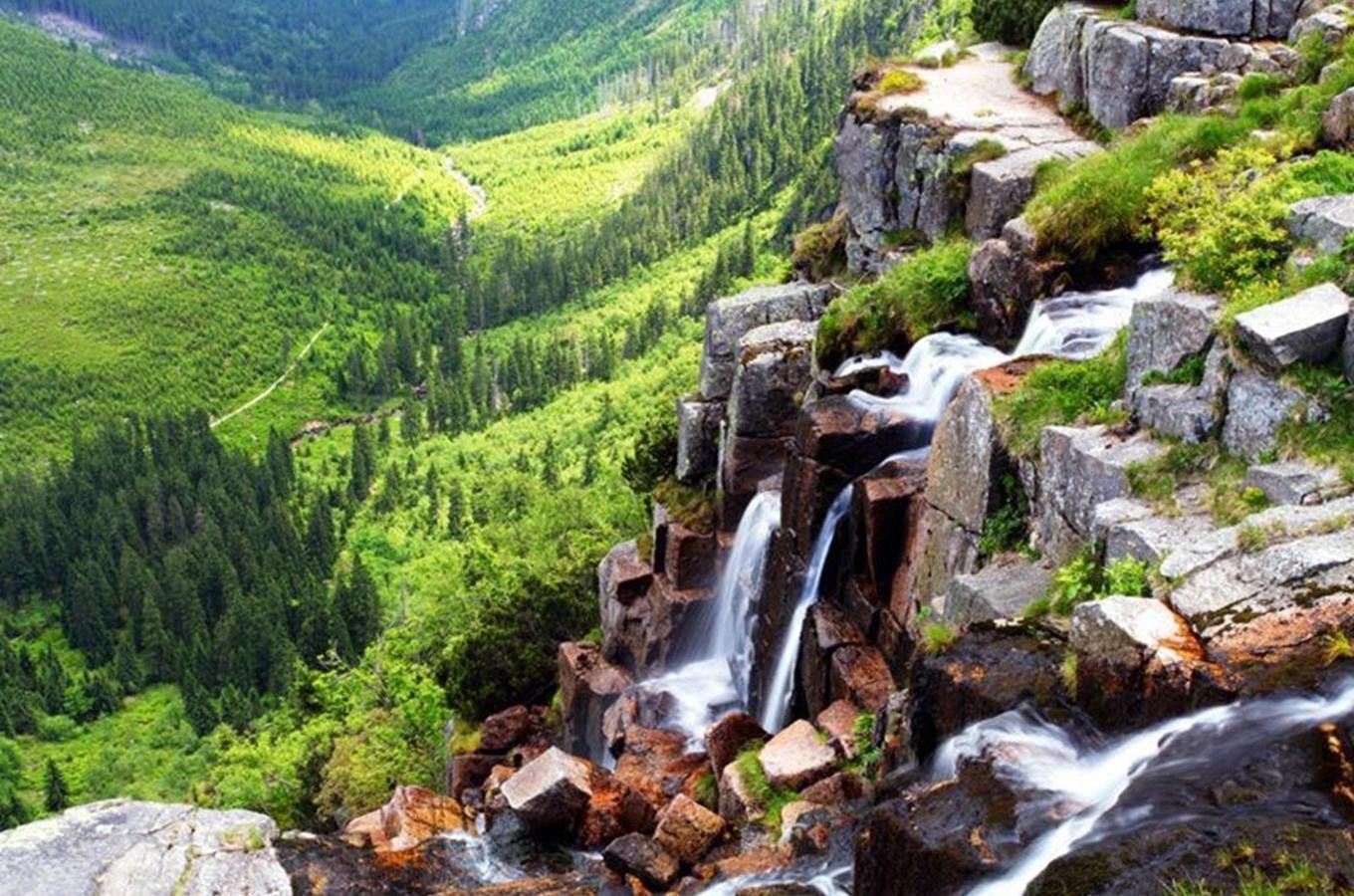
Fig. 2. Pančava waterfall (148 m) in the Krkonoše Mts. is the Czech highest waterfall (https://www.kudyznudy.cz/aktivity/pancavsky-vodopad-v-krkonosich).